Here's this week's posting from Port McNeill, well out towards the west end of Vancouver Island. Anne has updated the Google Map of our route. You can see that at:
True North Summary, June 24 - July 1
Already
a month has passed since we began sailing from Elliott Bay. This past
week was very fun with Marie and David aboard. They joined us at
Blind Channel, arriving by Coral Air Seaplanes from Campbell River,
having first driven from Portland to Anacortes, ferried to Sidney,
then driven to Port McNeill, caught a Greyhound bus to Campbell River
to catch the flight to Blind Channel. Nice planning! Meanwhile back
at the dock, with a current swirling in and around the marina from
the channel, Gregg masterfully backed in our boat after a go-around.
Pretty Blind Channel Resort is equipped with a laundry/shower, small
store, restaurant and lodge. The owner explained that on such a calm
day, most boats continue on their path north whereas in the summer or
in a blow, many more boats will take refuge there. We wasted no time
getting out on a first hike together to see the 800 year-old/16'
diameter cedar among the maze of trails. Not until we returned did we
see the sign to beware of bears, cougars and wolves!
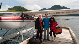

Marie and David with their Coral Air pilot
It
was a beautiful, clear morning when we left Blind Channel for Forward
Harbour. We needed to make it through Greene Point and Whirlpool
Rapids early. The scenery was enhanced by a couple of groups of
Dall's porpoises and snow-capped mountain vistas. Rounding a beach on
the tip of the B.C. mainland along Wellbore Passage, we spotted three
black bears on the very same beach where we saw one years ago. We
came in kind of close for a good look! Wow!

When we arrived in beautiful Forward Harbour, there were several boats already there. We anchored and immediately got to work setting out the crab pot. Once set, we took the dinghy to the beach to find the trail across the isthmus to a beach on the other side, this time with our bear spray in hand. When we got back to the boat we couldn't see our crab pot floats because the high tide had covered them! Gregg and David tried to find the crab pot when the tide was lower, around 2100 but couldn't find the floats in the dark water. Next plan: get up at 0100 at low tide. They brought the boat hook and a spotlight and returned promptly with the pot. They had found 5 large female crabs, all of which were returned to the water because only the males can be kept.

Bear on the beach, Wellbore Passage
When we arrived in beautiful Forward Harbour, there were several boats already there. We anchored and immediately got to work setting out the crab pot. Once set, we took the dinghy to the beach to find the trail across the isthmus to a beach on the other side, this time with our bear spray in hand. When we got back to the boat we couldn't see our crab pot floats because the high tide had covered them! Gregg and David tried to find the crab pot when the tide was lower, around 2100 but couldn't find the floats in the dark water. Next plan: get up at 0100 at low tide. They brought the boat hook and a spotlight and returned promptly with the pot. They had found 5 large female crabs, all of which were returned to the water because only the males can be kept.

Forward Harbor
Another night's anchorage brought us to Maltipi, site of an Indian midden and village as indicated by the deep layers of clam shells on the beach. On to Lagoon Cove the following morning, leaving early to make it through Chatham Channel reasonably close to slack water. We detoured to a windless Knight Inlet for several miles and around Minstrel Island on the way in order to take a look at the new scenery, and to try out salmon fishing - “mooching”. Knight Inlet is about 70 miles long and 2 miles wide, the longest of the fjords on the B.C. coast with steep rising shores and 6000' mountains close to the inlet. The famous Mt Waddington, a 13,000'+ mountain is a few miles from the head of Knight Inlet, however too far for us to see (even if the clouds had cooperated). We drifted for awhile in Knight Inlet while mooching for salmon but to no avail. However, we did spot a number of porpoises fishing in the tidal upwellings.

Marie "mooches" for salmon in Knight Inlet
Getting to Lagoon Cove early gave us the whole day to explore their setup with all the amenities, meet friendly people, check out the exercise stations (a woodpile with an axe!) and hiking trails. Bill and Pat had met us on the dock, then gave a thorough orientation talk. Pat told us that the potluck happy hour on the dock was required attendance! They supply a bucket full of freshly caught prawns and boaters bring the rest, including their own drinks. We were completely out of drinks with nowhere to purchase any when Bill, the marina owner, suggested we try to barter for a bottle of wine with the owners of a 86' Westport yacht which he noted had offloaded many (empty) bottles from the night before. Don, the generous yacht owner, kindly gave us two bottles of wine and wouldn't let us barter or purchase them, commenting, “That's just how boaters are.” So true that boaters do watch out for one another. Dave retrieved the crab pot he and Gregg set earlier to find that a huge sun starfish inside the pot had eaten the bait and whatever crabs had been there – only pieces were left! There was plenty of food at the potluck happy hour. Bill ended the evening with a few humorous stories, for which he's famous for telling over and over again.

Workshed, Lagoon Cove Marina
Such a friendly place made it hard to leave but we did move on towards Farewell Harbour on Berry Island where there used to be a popular fishing resort. Along the way we checked out Mamalilaculla for a possible anchorage, the site of the last great Indian potlatch on the coast, but found another sailboat already anchored and not much room for another. We continued on, circumnavigating Ralph Island for fun. We found the peaceful Farewell Harbour Lodge well protected from the 25 kt southeasterly winds, with five fishing boats at the dock but it looked vacant as no one was in sight. A dinghy run to shore for a closer look confirmed it was closed. Near the lodge we found a hiking trail and took off to look for the Chief's Bathtub on the north side of Berry Island but the winding trail took us further into the woods. At some point we began to think of bears and cougars! We had no bear spray with us so we broke out in a round of loud singing while making our way back to the lodge and our boat. Once back it seemed like a good hike but at the time, with no one else on the island, wild images had taken over. Later, another boat came into the harbor for the night.

True North and former Farewell Harbor Lodge
It
rained on and off as we made our way through Johnstone Strait,
putting up the sails to catch the wind for a short while, towards
Port McNeill, our next night's port 'o call, and via Alert Bay for an
afternoon tour. Alert Bay is very quaint with colorful houses along
the waterfront, totem poles, including the world's tallest at 173', a
fine museum with carved ceremonial masks and lots of artifacts from
the old potlach ceremonies, and carvers working on totems. Arriving
at Port McNeill in the early evening, Marie and David picked up their
car and we said our goodbyes after a very fun-filled week. Great
sports, those two, rain or shine.

Alert Bay
A
note about sailing these past couple of weeks: the good sailing takes
place mostly in the larger straits and channels. There isn't much
wind within the protected Desolation Sound and Broughton Islands,
except at night at an anchorage when one is trying to sleep
peacefully! I believe we went seven or eight days at one point
without even seeing a single sail anywhere.
No comments:
Post a Comment