Sunday, July 31, 2016

Crossing Hecate Strait to Haida Gwaii

June 29 – Spicer Islands to Queen Charlotte City Small Boat Harbor
The birds were still sleeping when we got up at 0315. We quickly made coffee, dressed for the dark, cold morning, and left the Spicer Islands. The forecast looked good: 5 to 15 kts, .4 meter seas at 12 seconds. The early morning departure was spectacular with a silver sliver of a moon shining over the tree tops and on through the water.
Early departure for Haida Gwaii
We sailed some of the time but mostly motored in calm seas with not another boat in sight until the last few miles. We were grateful for an easy crossing of what can be a stretch of wrathful fury under other conditions.
Smooth seas early in the trip
Landfall on Haida Gwaii was unusually striking with the very greenest of trees lining the shore as backdrop to a village of Haida style longhouses and totems that we later learned make up the Haida Heritage Center.
Haida Heritage Center
We passed by the more exposed Sandspit Marina, opting instead for the Small Boat Harbor in Queen Charlotte City, deep in the inlet, for the forecast the following night was for a big blow of 35-40 kts.. Just as we got close to the marina a steady, cold rain began which lasted until shortly after we were tied at the dock, enough to soak everything!

True North in Queen Charlotte City
First morning on Haida Gwaii: how exciting it was to be here, so far from everywhere! After checking in with the harbormaster, Gregg returned with a couple of peach-blueberry muffins from Queen Bee's near the head of the dock. Nice find! We were to find other good eateries during our stay, a welcome break from our more limited galley fare. For a morning stretch, we began walking the main road towards the ferry dock when an older Haida resident stopped to see if we wanted a ride to the Heritage Center, a couple of miles away. Sure! Along the way, Dick explained that he was starting a tour guiding business and asked if he might take us for a trial run so he could get a little feedback. We took him up on his offer the next day. In the meantime, we visited the museum with its huge collection of Haida artifacts and history, and tours of the totems and cedar weavings.
The Bill Reid totem pole, Haida Heritage Center
 A highlight of the day was meeting up with Mary and Lucy, friends from home who were finishing a road trip around north Haida Gwaii. They took us to Roberta's for a most unique dining experience, where her welcoming home overlooks Hecate Strait. Her Haida family prepares a beautiful meal with local seafood and as each course is served by her grand-daughters, Roberta describes the local delicacies: octopus, herring roe on seaweed, halibut soup, 3 kinds of salmon, and local strawberries with cream and cake. It was a great way for Mary and Lucy to end their time on Haida Gwaii and for us to begin ours.
Mary, Lucy, Gregg, Anne
We had a couple of days in QCC before picking up our rental car to tour Graham Island in the north. There were plenty of cruisers coming and going, a small but healthy farmers' market, a couple of grocery stores to visit and the Visitor's Center.
Absolutely exquisite giant tomatoes from the Farmer's Market
There were eagles everywhere in that harbor...lots of fish guts at the cleaning stations, too!
Eagle on mast, Queen Charlotte City
July 1: It was Canada Day but not much was happening in small QCC. We spent a couple of enjoyable hours touring with Dick Bellis, the Haida local who had volunteered to show us around. He introduced us to his nephew, an argillite carver of some renown living in a beach house nearby, and pointed out his own wood carvings which stand prominently around town.
Michael Brown and one of his argillite carvings
We stopped by Dick's home in Skidegate to see his small collection of old cedar woven hats, real beauties with an ermine skin attached at the tops.
Dick and one of his cedar hats
And he gave us a tour of the town, pointing out the totems and who lives here and there. Very interesting couple of hours!

For the next three days, we toured Graham Island by car. First stop was Tlell where we had reserved a cabin in a grassy clearing in the woods, not far from the more notable Haida House.
Our cabin in Tlell
Sweet! We lucked out there. It was spotless, cozy, and within walking distance to the beach on one side and just down the road to the best dinner ever at the Haida House.
Dinner at the Haida House
We hated to leave but did go on to Port Clements the following day. There used to be two big hallmarks there, both included in the town logo and both now gone: the legendary golden spruce, a 300-year-old Sitka spruce 50 meters tall and covered with brilliant golden needles, and which was felled one night by a conservation-minded logger, activist.
The fallen snag is the remains of the Golden Spruce
The other was the extremely rare albino raven that made an ill-fated landing on a live wire. There is a hike to the site where the golden spruce once stood, and the raven's remains live on in the logging museum.
Albino Raven, dead but not gone!
We hiked the trail, took in the logging museum, drove on to Massett, and then the Haida village of Old Massett where we found our B&B, located right on Massett Inlet. A walk through the old village, which was not full of historic native longhouses and totems as we had expected, brought us through the few streets of mossy covered wood houses and more modern totems standing. We found an “open” sign for an argillite carver and knocked on the door to find Myles Edgars, exquisite Haida argillite carver. He showed us a finely carved 15” totem. He would make us a deal...$7,000 instead of $10,000! We settled on a small raven instead, which he carved for us that evening and gave to us when we returned the following day.
Gregg with Myles Edgars and the raven he carved for us
A few miles down the North Beach road, we walked the well-maintained boardwalk to the top of Tow Hill, a prominent landmark with steep basalt cliffs overlooking Agate Beach and the ocean beyond.
Tow Hill, North Beach, Graham Island
Our brief road trip ended where it began in QCC on a cold, rainy day with a high wind forecast. There were at least a half dozen other boats waiting in the marina for a fair weather break before setting out south to Gwaii Haanas National Park where the anchorages at the Haida cultural sites have sketchy holding with lots of rocks! There are a few mooring buoys but none of us knew if they were secure. We passed some of the extra time at the visitors center watching a very moving film about the repatriation of Haida ancestral remains from a Chicago Museum.

Balance Rock, Skidegate

Eagle, Skidegate
Two main islands plus 150 islets make up the Haida Gwaii archipelago. It lies on the western edge of the North American continent with a deep trench just off the coast. There have been two major earthquakes on Haida Gwaii, the most recent a 7.7 mag in 2012. Definitely not the place to be in a small boat during a tsunami! Haida Watchmen conduct tours at the five abandoned Haida cultural sites, with no more than 12 visitors touring at a time, keeping it serene. There are no roads within the National Park. Each visiting boat calls the watchman cabin, waits for permission to come ashore, then is typically greeted at the beach by a watchman for about a 1-1/2 hour guided tour in an enchanting environment that holds a very strong sense of its ancient spirit.
Hoisting our Haida Nation courtesy flag below the Canadian flag.  Note ski hat, woolen hoodie in July!
Finally, July 9th as the weather cleared for leaving, the marina cleared out! The first black bear sighting motivated us to reach for the binoculars at every passing beach.
Black bear looking for seafood treats
Over the next two weeks we found a few other bears, whale sightings almost daily, and tons of seabirds. Don't ask! It wasn't easy to match them with the bird pictures! Our first destination was Skedans, aka K'uuna Llangaay, located on the NE end of Louise Island. We anchored securely in a pretty, open cove with low rocky islands nearby.
Temporary anchorage at Skedans
The boat Coast Pilot, friends of Seattle friends, gave us a lift to shore in their skiff where a young Watchman Nick met us at the beach and showed us around.
Watchman Nick telling us the history of Skedans
What remains today are a few standing carved memorial and mortuary poles and the mossy covered logs and depressions where several longhouses had been. The tidal range is huge throughout the islands meaning that during the tour, Ian made his way back to the beach to move his heavy skiff a little higher ashore!
Gregg, Ian, Linda, Watchman Nick at Skedans
We sailed a few hours after leaving before heading to the secure anchorage in Thurston Harbor. Eight other boats came into the harbor that night, and Coast Pilot joined us for happy hour, a very fun evening with Ian and Linda.
Coast Pilot and Raven at Thurston Harbor.  Note logging scars - still outside the Park.
The next morning we motored over to Tanu (T'aanuu Llnagaay). Again, we hitched a ride to shore with Coast Pilot. True Dink was still tied down on deck. Our Watchman Walter met us along the beach to show us a map posted to a tree with a sketch of the village the way it once was, circling the beach with 25 to 40 longhouses in a village, many mortuary poles and houses.
Watchman Walter with cedar map of Tanu
Today there are mostly the abandoned remains of moss covered house posts.
Remains of longhouse, Tanu
It is a very spiritual place for the Haida as there are burial sites along the hills. Walter brought us to his cabin where his wife Mary and their young daughter graciously served up a batch of hot fry bread they had just prepared. Such a warm welcome!
Walter and his daughter
Mary's fry bread at Tanu
Walter, Ian, Linda, Anne at Tanu
Windy Bay (Hlk'yag GawGa), the next Haida site we visited was just 1-1/2 hours south so we motored on while the good weather continued. We tried to catch a mooring ball but seeing a 12' depth with a rocky shoreline nearby, backed off. Scarily shallow! We tried 3 times to set the anchor in the rocky bottom to no avail; same for Coast Pilot so they decided to move on. As the tide was rising, we checked the mooring ball again to find it acceptable at 17' and rising. Fine for the 1-2 hours we would be there! We dinghied to a rocky beach shore and wheeled True Dink high onto shore. We had to cross a couple of rising streams to get to the Watchman Vince and we did get wet! A jovial group of five kayakers from Calgary touring with the charter boat Island Bay waited for us to join them.
Watchman Vince at Windy Bay
Windy Bay is located on the east side of Lyell Island, one of the sites where Haida protested logging in a stand-off against loggers in the 80s. It led to the creation of Gwaii Haanas National Park and Heritage Site and the end of rampant logging within the park. There is a Legacy Pole on the beach, the first monumental pole raised in Gwaii Haanas in 130 years, which commemorates the 20th anniversary of the cooperative management between Canada and the Haida. The main attraction at Windy Bay is a hike through old growth western hemlock, western red cedar and Sitka spruce, with one giant 800-900 year old Sitka spruce.
Hiking at Windy Bay
Anne and giant Sitka spruce, Windy Bay
There are a few mossy logs near pits remaining but no vintage totems here. As the wind picked up in the late afternoon we took refuge in Haswell Harbor, an anchorage described as bombproof. We stayed for two nights, soaking in a little R&R – no tides to concern us from the center of the anchorage, well-protected, and with two streams of cascading water. A resident eagle perched high above scanned the outflow for an easy meal. Meanwhile, we dinghied around the bay at low tide to walk the rocky shoreline and while in this pretty little harbor, celebrated our anniversary, #24!

Haswell Bay
July 12: Haswell Bay to Hotsprings Island to Bag Harbor – 0700 departure for Hotsprings Island (Gandll K'in Gwaay.yaay), the 4th cultural stop for us. An early arrival might increase our chances of securing the only buoy. There wasn't a single other boat around! We took the dinghy to shore and met our watchman David for a walk around the natural hot springs.
Gregg and Watchman David with a (former) hotspring tub, now cold
Mostly they are the former hotsprings. This used to be one of the most popular stops for cruisers, kayakers, tours and seaplanes stopping by for a soak but the earthquake in 2012 changed the landscape so there isn't much water filling them now. The tide was ebbing and the shallow water where our dinghy was anchored was drying quickly so we left after a brief tour.

A bumpy 3' chop was coming from the SE. The forecast wasn't expected to be good for the next few days. We were working our way around to Rose Inlet, and Anthony Island (SGang Gwaay), a small island off the southwest coast of Moresby, the last stop on the cultural tour and a UNESCO World Heritage Site, but it looked like it would be another 5 days before we could safely anchor there because of a the high wind. Anticipating the worst we tucked into Bag Harbor, a wide, almost lake-like anchorage at the south end of Dolomite Narrows. It was completely calm with the added serenity of a mountain view at the end of the harbor.
Bag Harbor, very protected
Two other sailboats arrived for the night. It had been a great day for wildlife sightings! Along the way we spotted a large black bear on the rocky point at the south end of Burnaby Island turning over rocks scavenging for food, and earlier in the day we encountered dolphins, a humpy, and a single seal though we didn't see a single boat.
Humpback showing flukes
July 13: We got a lucky break in the weather the following day so proceeded to Rose Harbor, also well protected. We found Coast Pilot already there. They had been to SGang Gwaay earlier that day and, as it was getting late with a forecast for foul weather the following day, we pulled our anchor to make a run for it then.
Leaving Rose Harbor for SGang Gwaay, Coast Pilot at anchor
It was easy going. We anchored in the north anchorage where the holding can be just fair, but the weather was calm and our anchor took hold.
True North in the Northwest temporary anchorage at SGang Gwaay
A few kayak groups were leaving as we arrived and were greeted at the Watchmen cabin by Donna, our guide. She took us to see a few standing totems first.
Watchman Donna discussing the poles at SGang Gwaay
They were carved before the village was abandoned in the late 1800s. Most of them had fallen over with age but these had been carefully placed upright again in 1975. The moss covered signs of abandoned longhouses remain overlooking the bay, and the beyond them stand another dozen totems.
Gregg and Anne with SSPS burgee, SGang Gwaay
This was the last village to have been occupied on a full-time basis. A hill at the far end of the old village marks the burial ground where thousands of Haida ancestors who died from smallpox are buried. For this reason, it is a sacred site. This splendid site holds a certain mystique and was our last stop on the cultural route.
Totem Park at SGang Gwaay
Abandoned longhouse behind the totems, SGang Gwaay
There are other abandoned Haida sites but sailing along the perilous western rocky shore to access them in fair holding held no appeal! The watchmen were awesome with their friendly hospitality, and keeping their cultural history alive was much appreciated.

We remained in Rose Harbor three days longer than planned because we were both feeling a bit under the weather, trading turns at needing another day to recover. It gave us a lot more time to explore the remains of an old whaling station and talk with the locals, as well as other cruisers coming and going – Relentless, Great Bear, Good Fortune, and tiny, 24' SoSo.
Haida canoe in forest, builders died of smallpox before they finished it
Gregg with whale bone relic at old whaling station

Rose Harbor has rocky outcrops and islets which harbor an abundance of seabirds. If we were to guess which birds we saw after carefully comparing with a guidebook, our list would now include many noisy oystercatchers, majestic eagles, squawky ravens, a blue heron, glaucous-winged gulls, marbled murrelets, and many other little grey or black or white birds we couldn't identify.
Anne at the helm of True Dink
July 18: Nice as Rose Harbor was, we were ready to move on. The day came with a NW wind on the bow of about 4 to 8 kts so was an easy bash. As we approached NE corner of Burnaby Island, a yacht coming our way called to advise us of the rip tides ahead which were barely visible to us, but as we altered our course away from land another two miles we could see we avoided 6' waves. We anchored in Hutton Cove at the mouth of the inlet. It is beautiful! We set the crab trap and settled in to soak up the sunlight. Then the wind picked up..... Because this was an anchorage of only fair to good holding, we decided to test the anchor again, pulling it hard. It held, then slipped, held, slipped. We left and went to the more secure head of the inlet for a peaceful night.


After a refreshing three hour sail through Darwin Inlet in full sun we arrived at Echo Bay, a beautiful setting with many birds, a waterfall and places to walk. Not another boat in sight all day!

Gregg heard the hwoosh of a whale and after a quick scan a humpy surfaced about 100' off our port side...that's close! We sailed to more scenic anchorages on the way north, Anna Inlet, McEchran Cove, and finally Crescent Inlet where we spotted three bears in the grassy area at its head. Plenty of bears and eagles but no crabs in our pot! Sandspit Marina was the final stop for this part of the passage where we docked True North among a crowd of small fishing boats to prepare for a weather break and our return to the B.C. mainland. Next leg: crossing Hecate Strait east to get back to the B.C. mainland.
Gregg and Anne do a selfie in Anna Inlet


Tuesday, July 5, 2016

Port McNeill to Prince Rupert


June 11 – Crossing Cape Caution to Northern British Columbia
We made our way efficiently to the north end of Vancouver Island, then left on the 10th from Port McNeil through Goletas Channel where we checked out God's Pocket as a potential anchorage. It is a small scuba resort which looks quite inviting with its colorfully painted wood buildings.
God's Pocket Resort
However it was a bit breezy in the small anchorage so we decided to move on to Port Alexander, anchoring in completely calm water, protected from the NW and surrounded by trees on three sides. There were tons of huge, fresh logs stacked on the beach at the south end. Accordingly, Waggoner's cautions this is not the place to be in a southerly!

Next day, the anchor was up at 0615, ready to catch the ebb north to Cape Caution. We would be crossing the southern part of Queen Charlotte Sound where the Pacific fetch is long and can create steep waves over the shallow shelf we would be sailing. We left the dock with one reef in the main, first motoring west through Gordon Channel so we could then sail north all the way past Cape Caution in the NW wind as forecast: NW 5-15 kts increasing to NW 15-20 by noon, diminishing to 5-15 to evening. SE 15-25 Sunday morning. The wind did not develop as forecast! It fluctuated between 9-15 kts, only it was a southerly which, mixed with the 2' westerly swell, made the sails bang from side to side. Even so, in the light wind we did sail 3 kts SOG all the way past Cape Caution! Low stress, the way we like it, compared with how it could have been with big wind and the resulting waves.
Two miles off the dreaded Cape Caution
Our destination was Fury Cove, tucked off the west side of Fitz Hugh Sound. By its description it would be a perfect anchorage with a white shell beach at one end where views of the Pacific beyond could be seen. Then, weighing prudence against beauty, we decided to first check out the more secure Fry Pan and Big Fry Pan coves further east in River's Inlet, for the southeasterly was by this time expected to reach 30 kts. Both anchorages were securely surrounded by trees with nowhere to get off the boat and boring! So we left for Fury Cove, mindful of an escape plan to Secure Anchorage if needed, and found the beautiful cove as described, plus nine other boats already anchored. A group of cruisers from Gibson's Landing was heading towards shore for a sunset dinner rendezvous. As for the big blow overnight, it never developed!
Fury Cove anchorage
Morning in Fury Cove: drizzle and light wind....shore excursion cancelled! Several other options: Dawson's Landing, an old-time general store with docks and a few fishermen cabins in Darby Channel off River's Inlet, or head out to Fitz Hugh Sound while a good sailing wind prevailed. We decided to do both. With just the jib flying we were sailing effortlessly in Fitz Hugh at 6 kts with 24 kts wind astern.
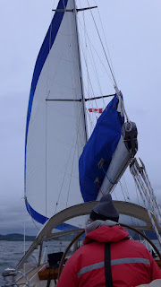
A rare sight - sailing!
We jibed a few times, once making a spectacle of ourselves when the sail wrapped around the furler while jibing in a sudden gust, before sailing towards Dawson's. There are many place names inside these passages which conjure up vivid images that one must see first-hand in order to compare with reality, and Dawson's Landing was one of them. The old place looked deserted and a bit hardscrabble on approach but we had arrived in a downpour.
True North at Dawson's Landing
We tied up at the dock and went to the general store to see if we could stay. It was Sunday and closed but Nola the owner let us in to visit and look over the well stocked shelves.
Guard dogs on the counter in Dawson's Landing Store
We inquired about River's Inlet Fishing Resort, one of Kenmore Air's former stops. She told us there used to be 11 fishing resorts in River's Inlet when they took over the operation 27 years ago from her parents, who ran the place for the previous 35 years. Now there are just two because it's way too costly in these remote areas for the small lodges to treat water and sewage to acceptable standards, though many have tried and failed. While we thought we might pick up a few items and head over to Beaver Cove for the night, we decided it might be a good idea to just stay put and support their business. A hot shower isn't a bad idea, either!

June 13 – Dawson's Landing to Pruth Bay at Hakai
First thing the following morning, the local staff at Dawson's was busy moving little white wooden float houses from their winter protected area of the bay to their summer locations alongside the dock on which we were tied. What an operation! One guy pulls, then pushes the structure with his boat while two others stand at the front of the float with boat hooks to gently guide it as they reach the dock. We stayed to watch as we were in no huge hurry to leave this morning for the few hours to Hakai.
Re-arranging the float houses, Dawson's Landing
We started the watermaker on the way out of Darby Passage and, now curious, checked the water purity to find it extremely pure at 43 ppm (200 ppm is acceptable for us). From Darby, we crossed Fitz Hugh Sound enroute to the well-protected Pruth Bay at the head of Kwakshua Channel. Fortunately, we left the dark clouds behind! We entered the anchorage with blue sky and sun to find a scenic anchorage and Hakai Beach Research Institute at the head of the bay with a beautifully maintained lodge and grounds.

Photo op, Pruth Bay, Hakai
Boaters are welcome to hike trails to nine nearby beaches through the woods on boardwalks over to West Beach, a wide white sandy beach open to the Pacific. It was a much needed stretch so we continued along to a hilltop look-out with outstanding views of the ocean.
Boardwalk trail up to Lookout Mountain, Pruth Bay, Hakai
There were nine other boats in that splendid bay, lined up in rows along each side of the bay, leaving a wide center stage for seaplane landings.

June 14 – Pruth Cove to Brydon Anchorage
A full-on steady rain greeted us on waking in Pruth Cove. While gazing out from under the dodger, Gregg spotted a humpback whale swimming through the anchorage just off our port side! It surfaced twice before disappearing.
Humpback in the anchorage, Pruth Bay, Hakai
It was still pouring and already past our 0930 planned departure time. Could not decide, shall we stay or shall we leave? By 1100 the hard rain turned to drizzle so we pulled the dinghy up on deck and took off. Almost immediately, it became inexplicably pleasant out on the water! We motored out of Kwakshua Channel into Hakai Passage, passing Hakai Lodge, a destination for Seattle seaplane charters, then into Kildidt Sound past the Kittyhawk Island group, navigating through the charted rocks and now under sail into Brydon Channel to Brydon Anchorage where there are three cove choices.
Hakai Lodge
We checked out each one, anchoring in 30'. This place has solitude with a capital S! Except for the thousands of butterfly jellies which became the entertainment, the views were not interesting.
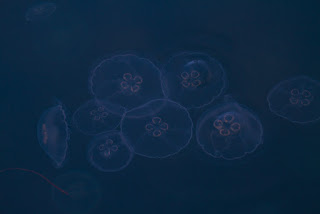
Thousands of jellies
Then as that activity got old, Gregg cast a fishing line and within minutes caught a small bright rockfish. He was unable to disengage the hook so we kept it for dinner. The disappointing truth is that we fished all through Hakai Passage which is noted for 40 to 50 lb. salmon and we didn't catch a thing!
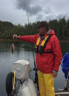
Giant rockfish catch
June 15, 16 – Brydon Anchorage to Shearwater Marina, Bella Bella
Today's destination: Shearwater and Bella Bella. After leaving Brydon Anchorage we motored into Queen Sound. The wind had not been cooperating for sailing much lately. We were sure we'd have a good run in the upcoming Queen or Cultus Sounds but no such luck. While in Cultus we spotted two otters, one right in front of us in the center of the channel chomping on a fish, unfazed by our passing.
Our first sea otter sighting of the trip
Next came Lama Passage and then Shearwater Marina. There were lots of boats already there including the group of cruisers from Gibson's. We pulled into the last space along the outer end of the T-dock with a good view of the harbor towards Old Bella Bella. It was late in the day but we wanted to see Bella Bella, another place name of intrigue. We took the 10-minute water taxi across the bay to find the four totems the taxi driver had told us about, returning about an hour later...not much else there.

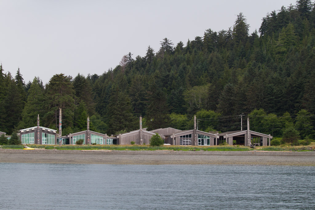
School totem pole, Bella Bella
On the second day it rained all day long, and on into the following day. We were desperate for a walk so began the 1-1/2 miles on the muddy road to the coast guard station at Old Bella Bella but the puddles were too deep for our shoes. We opted for dinner out with pub pizza where boaters from four different tables engaged in lively talk about past and upcoming routes. More cold rain!
Shearwater Marina
June 17 – Shearwater to Quigley Creek Cove
Left the dock 0630 heading north then west into Seaforth Channel. We had a little wind so we put up the jib for an hour of gentle sailing.
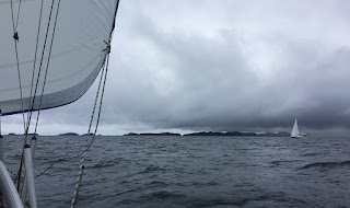
Sailing for another hour or so, and another sailboat in sight!
We navigated through the narrow passage ahead, moving along to Cod Bank, then across Milbanke Sound to the west side of Price Island, north through Laredo Sound into Laredo Inlet to Quigley Creek Cove. It had been calm and grey most of the day but as we made our way through Milbanke Sound the sky brightened up a little. Unfortunately we kept moving towards the thick, darker clouds. But as we made our way into Laredo Inlet and Quigley Creek Cove, incredible! Sun, blue sky, and warmth for a gorgeous evening. There were very scenic rocky ledges along the shoreline and trees with rounded mountain views. Many eagles! Went to sleep without a cloud in the sky.
Verrrry calm waters in Quigley Creek Cove.
June 18 – Quigley Creek Cove to Bent Harbor
Leaving Laredo Channel we picked up a good NW wind as we sailed SW towards the southwest tip of Aristazabal Island. We were heading for the outside coast along Hecate Strait where wild but protected anchorages dot the coastline. The wind was superb, providing much sought after sail time in full sun! Enroute to our anchorage in Weeteeam Bay, Bent Harbor, the wildlife sightings picked up dramatically with a couple of humpback whales, dolphins and another sea otter! Bent Harbor's scenic landscape is made up of low lying rocky areas that provide distant views directly into Hecate Strait to the west. It is otherwise protected by trees with another cutaway view to the south so it offers both protection and openness beyond the anchorage. Awesome day!
Sailing with both sails up!
June 19 – Bent Harbor to Tate Cove, Borrowman Bay
Onward north. Imagine our surprise at motoring through the potentially worrisome Hecate Strait with not enough wind to sail! We motored along the west coast of Aristazabal Island to Borrowman Bay at the northwest end and caught sight of a humpy show to our delight. There were several bright green boats in the distance also watching the whale. On closer view we could see they were from North King Lodge which we passed on the way into Tate Cove.
Entrance to Tate Cove, with North King Lodge charter boat
We immediately clicked with this anchorage. It was full of eagles, grebes, and has an interesting shoreline with places to go. After not being able to get off True North for three days we quickly launched the formidable True Dink to check out the surrounding places. We'd be able to put out the crab pot here! We walked the shoreline to see flotsam and jetsam creatively decorating a beach, then made a stop at the North King Lodge to find a friendly staffer who talked fishing with us and showed us around the docks with its heli pad for guest arrivals. They have twenty fish boats out on the water and run the lodge continuously with two groups each week all season long. The well-maintained lodge is on floats and is moved to Prince Rupert during the winter months. Back at the boat, we deployed the crab trap in about 45'. We checked it with high hopes later in the evening but found nothing. Our bait, suggested by a clerk in Port McNeill, was a bit unusual: a sponge soaked in Bait Fuel! There was another payoff, though: the sunset looking directly west over Hecate Strait was spectacular with clear skies overhead.

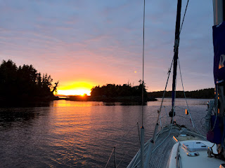
Surreal sunset in Tate Cove
June 20-21 – Weeteeam Bay to McMicking Inlet
It was hard to leave Tate Cove because it offered so much of interest. Nevertheless, we did leave because the forecast indicated very strong wind and rain on the 21st which, if we stayed, would mean two additional nights and too many for the pace we set to get ourselves further north. It hasn't felt hectic to keep moving on; rather,  purposeful, moving towards our goal of being in a place where we can safely wait for a good weather crossing of Hecate Strait and still arrive in Haida Gwaii in time to keep a few reservations we made. Those are the plans, in sand...

This was our best sailing yet with a crystalline day and wind any sailor could happily embrace. The freedom of traveling by wind power still impresses! We had rounded the north end of Aristazabal Island through Caamano Sound under full sails to enter into Estevan Sound earlier than expected and then navigated the charted rocky McMicking Inlet. Pender Mountain to the east provides a dramatic granite backdrop to the anchorage.
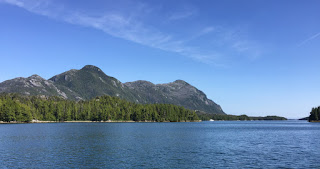
Pender Mountain with Sea Drifter in the distance, McMicking Inlet
We had seen only one other recreational boat all day but here in the inlet we passed an anchored yacht on the way inside. They motored over in their fish boat to say hello, came aboard, and we met Doug and Jan on Sea Drifter from Olympia, Washington. They stopped by again a little later to bring us two huge Dungeness crabs. We had just finished dinner so we gave the crabs an overnight home in our crab trap, hung off the stern. The following day proved the weather forecast to be correct: a strong southerly wind throughout the day with gusts in the mid-30s and constant, cold rain. The wind howled until mid-afternoon. We kept a vigilant watch on the shoreline and ear to the anchor alarm as we swung around. Meanwhile, to pass the time indoors we read and baked dill bread to accompany the evening crab dinner. And that is how we spent Summer Solstice, 2016!
Cleaning the crabs graciously provided by Sea Drifter
June 22-23 – McMicking Inlet to Patterson Inlet, Princess Diana Cove
Back to sun the next afternoon brought a show of two pods of Orcas and humpbacks on the way to Princess Diana Cove at the end of Patterson Inlet.
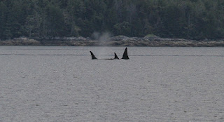
Orca whales
Happy to be in a cove with landfall opportunities, we dinghied around the cove, walked the rocky shoreline.
Tiny crab on barnacles
On the way back, we stopped to say hello to Commodore II with John and Randy aboard. They told us the neighboring boat, Segue II had been in Haida Gwaii so we later found them and spent a couple of hours visiting with David and Kaye, an interesting couple with many years of boating experiences throughout the South Pacific, Europe and Scandinavian countries in particular, first sailing and now in a Nordhavn 47.
Princess Diana Cove, Patterson Inlet
From Patterson Inlet we motored about 3-1/2 hours to Colby Bay, very pretty and with no other boats present. We dinghied to shore to check out the old growth cedars. They weren't immediately visible but we made our way through the mucky mud, still not seeing the cedars. The woods, mysterious by nature, drew us in about 50' from the beach where we did see several awesomely large cedars.

Next up, an easy day motoring to the Spicer Islands. This is a good protected anchorage to wait for a weather window for crossing Hecate Strait only we arrived a few days earlier than necessary. We anchored just off Spicer inside the second passage with a slim view beyond the anchorage to Hecate Strait. It was again cold and grey and we were feeling quite isolated from the world. We could either wait there in the expected drizzle for three days until suitable weather for crossing Hecate Strait or go someplace else. We chose the latter almost as soon as the thought took shape and bolted 35 nm north to Prince Rupert the following morning. We were ready for civilization and found it!

June 26-27 – Prince Rupert
Sunshine brings optimism and with it smiling people! The beautiful new Cow Bay Marina with helpful and friendly marina staff, wifi, clean showers and laundry confirmed that it was a good decision to make the detour to Prince Rupert.
Prince Rupert marinas
The very first thing we did was to get off the boat and walk. We were both a little wobbly getting our land legs back but walked around town and through residential streets to see colorful, lovely old homes overlooking the bay, visiting with a few locals who were outside in their front yards. There were also several boats we had met at anchorages along the way with which we visited over our day and a half break.
The benefits of civilization
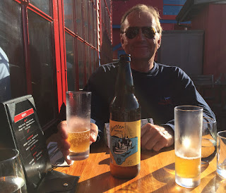
It became a mini vacation from our vacation being in this pretty port town with several good restaurants, IPAs, a couple of good museums, and streets to roam.
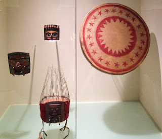
One of many fabulous displays, Museum of North British Columbia
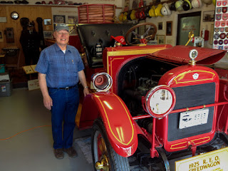
1925 REO Speedwagon fire engine and the fellow who restored it, Fire Museum
June 28 – Prince Rupert to Spicer Islands

We were reluctant to leave the mini-paradise of Prince Rupert but we were facing a slim weather window over the next few days for crossing Hecate Strait so back to the Spicer Islands we went with plans to cross on the following day, forecast to be a good weather day. We did and it was! But we'll describe that next time!